

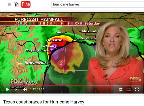
Bão Harvey có thể đưa các trận mưa tầm tã, gió mạnh và sóng lớn tới Texas vào cuối tuần này.
Bản tin của cơ quan khí tượng AccuWeather nói rằng sau khi ra khỏi khu vực bán đảo Yucatan ở Mexico, bão Harvey sẽ di chuyển theo hướng Tây Bắc và qua vùng biển vịnh Mexico hôm Thứ Tư.
Nhiều nơi ở bán đảo Yucatan sẽ có mưa lớn và sấm chớp dữ dội từ nay tới Thứ Tư.
“Chúng tôi chờ đợi là Harvey sẽ tái tạo khi qua khu vực biển ở phía Tây vịnh Mexico, tăng thêm sức mạnh, trong khoảng thời gian từ Thứ Tư tới sáng sớm ngày Thứ Sáu,” theo chuyên gia khí tượng Dan Kottlowski thuộc AccuWeather.
“Chúng ta sẽ thấy mưa lớn, sấm chớp và sóng mạnh ở Nam Texas và Đông Bắc Mexico khi Harvey tiến gần. Mối lo ngại lớn nhất sẽ là lụt lội,” cũng theo ông Kottlowski.
Đường di chuyển, sức mạnh và sức gió của Harvey sẽ quyết định lượng mưa trút xuống các khu vực này.

Nếu bão tiến xa hơn về phía Bắc dọc theo bờ biển Texas, mưa lớn và nguy cơ lụt lội sẽ mở rộng ra tới Louisiana.
V.Giang
***
Hurricane Harvey Discussion
NWS National
Hurricane Center Miami FL
400 AM CDT Fri Aug
25 2017
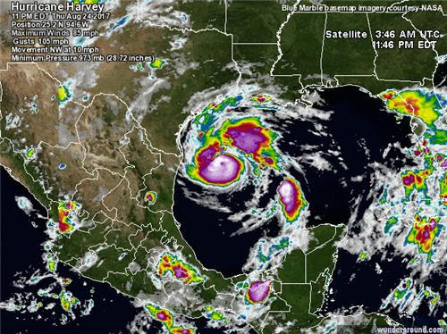
The satellite
presentation has improved during the past several
hours with an
intermittent eye feature surrounded by a ring of very
deep convection.
There are various cyclonically curved convective
bands primarily to
the north of the eye and the outflow is fair.
NOAA and Air Force
Hurricane Hunter planes penetrated the eye
various times during
the past several hours, and the most
significant data
were a flight-level peak wind of 103 knots, and a
peak SFMR surface
wind of 88 kt. The central pressure dropped
to 967 mb. Based on
these data, the initial intensity was adjusted
upward to 90 kt.
Another reconnaissance plane will be in the eye of
Harvey shortly.
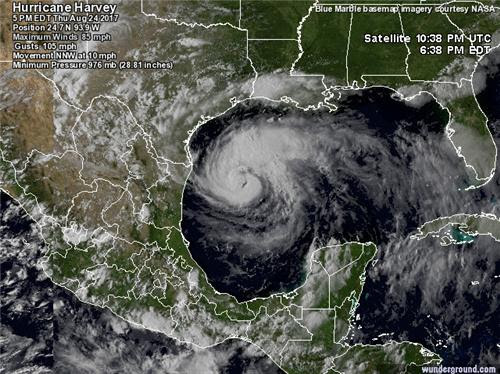
Since Harvey is
embedded within light shear and moving over warm
waters, additional
strengthening is anticipated before landfall in
about 24 hours. Thereafter, gradual weakening is forecast but
since
a good portion of
the circulation will remain over water, the
weakening process
could be slower than normal.
Radar and
reconnaissance fixes indicate that Harvey is moving toward
the northwest or 320
degrees at 8 kt. The hurricane is on the
western edge of a
persistent area of high pressure over the eastern
Gulf of Mexico, and
this pattern will maintain the current hurricane
motion until
landfall. Once Harvey is inland over
Texas, the
steering currents
are forecast to collapse and the cyclone should
begin to meander,
prolonging the flooding conditions for several
days. The track
guidance between now and landfall is very consistent
and there is high
confidence in the track forecast. After landfall,
the track models
show large variability and the confidence is low.
In any case, NHC
forecast depicts a slow moving tropical cyclone
near or over Texas
for the next five days.
Once again, it is
very critical that users not focus on the exact
forecast track of
Harvey, since cycle-to-cycle adjustments are
likely. All locations within the hurricane and storm
surge warning
areas should be
preparing for the possibility of major
hurricane-force
winds and life-threatening storm surge.
Key Messages:
1. Harvey is
expected to be a major hurricane at landfall, bringing
life-threatening
storm surge, rainfall, and wind hazards to portions
of the Texas coast.
Preparations to protect life and property should
be completed this
morning, as tropical-storm-force winds will first
arrive in the
hurricane and storm surge warning areas later today.
2. A Storm Surge
Warning is in effect for much of the Texas coast.
Life-threatening
storm surge flooding could reach heights of 6 to 12
feet above ground
level at the coast between the north entrance of
the Padre Island
National Seashore and Sargent. For a depiction of
areas at risk, see
the Storm Surge Watch/Warning Graphic at
hurricanes.gov.
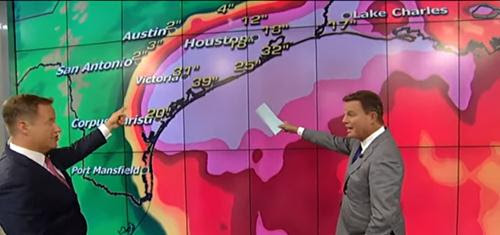
3. Devastating and
life-threatening flooding is expected across the
middle and upper
Texas coast from heavy rainfall of 15 to 25 inches,
with isolated
amounts as high as 35 inches, from today through next
Wednesday. Please
refer to products from your local National Weather
Service office and
the NOAA Weather Prediction Center for more
information on the
flooding hazard.
4. The Potential Storm
Surge Flooding Map is available on the NHC
website. This
product depicts a reasonable worst-case scenario -
the amount of
inundation that has a 10 percent chance of being
exceeded at each
individual location. This map best represents
the flooding potential
in those locations within the watch and
warning areas.
FORECAST POSITIONS
AND MAX WINDS
INIT 25/0900Z 25.9N 95.4W
90 KT 105 MPH
12H
25/1800Z 26.9N 96.3W 105 KT 120 MPH
24H
26/0600Z 28.0N 97.1W 105 KT 120 MPH
36H
26/1800Z 28.5N 97.4W 65 KT
75 MPH...INLAND
48H
27/0600Z 28.5N 97.5W 60 KT
70 MPH...INLAND
72H
28/0600Z 28.3N 97.0W 35 KT
40 MPH...INLAND
96H
29/0600Z 28.5N 96.0W 35 KT
40 MPH...OVER WATER
120H 30/0600Z 29.5N 95.0W
35 KT 40 MPH...INLAND
Forecaster Berg
No comments:
Post a Comment
Note: Only a member of this blog may post a comment.